|
|

|
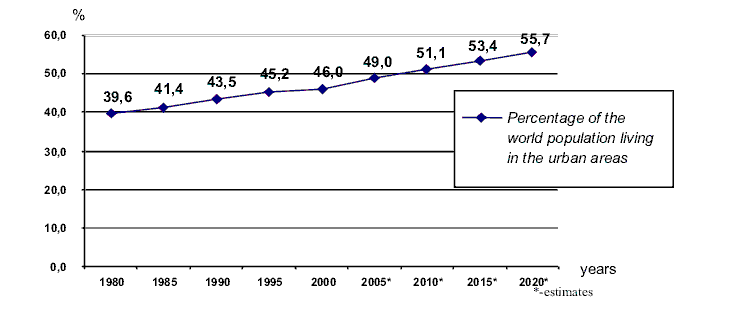
FACTORS DETERMINING THE MANAGEMENT OF THE TRAFFIC CONGESTION IN THE URBAN AREA Zbyszko Pawlak ABSTRACT The aim of the article is to investigate factors that can affect management of the traffic congestion in the urban area. The predictions according to the theoretical background presented are that such factors as: migrations (commuting), location within a functional zone, road constructions, presence of public institutions and facilities, traffic network arrangement, suburbanisation, significance of the route, road type, presence and the nature of junctions, grade crossings, bridges or public transport presence can to a different extent influence the traffic congestion pattern. The level of this influence in the urban area of Poznan (Poland) is stated using the self-created indicator - Synthetic Congestion Ratio (SCR). Moreover, it was predicted that the traffic volume is higher on week days than during weekends. In order check the truthfulness of the hypotheses the research was conducted by establishing some checkpoints near crossings where investigated factors are present and later by measuring the traffic volume in the urban area researched. The conclusions are that the most influential factors determining the management of the traffic congestion in the urban area are: level of road's significance as a communication route, central business district (CBD) approach or thoroughfare and road type (expressway, two-lane, multi-level junctions), whereas the other factors' influence is significantly smaller (streets' layout, facilities attracting people, location within a functional zone). Furthermore, it was observed in one of the checkpoints that there was a discrepancy between the predicted and the actual traffic volume. This was probably a result of yet another, not known (not taken into consideration) factor e.g. car accident. INTRODUCTION The problem of traffic congestion management concerns every bigger urban area in the world (although sometimes the issue is influenced on by the level of the economic development) and due to the fact that more and more people live in urban areas than in the rural, this trend is expected to continue in the future. By the term traffic congestion the following phenomenon is meant - the accumulation of vehicles leading to overloading of the traffic network and problems from it resulting [Szymczak 2002]. An urban area is an area with an increased density of human-created structures in comparison to the areas surrounding it [Pawlak 2006]. As it can be observed in the diagram (Fig.1) it is predicted that by the year 2020 more than 50% of the world population will have been living in the urban areas. Such an increase will surely lead to the increase of the usage of cars which may lead to the growth in the traffic congestion. This means that the problem will be acquiring importance.
The management of the traffic congestion is very closely connected to the process of urbanisation and this trend is true for both economically more and less developed countries. The most important role of the traffic transportation network is linking people, resources, activities and enabling the exchange of goods (trade) and ideas (information). However, different types of transports are appropriate in different situations and the road transport will be the most appropriate in the urban areas, because of [Waugh 2000]:
However, the development of a given area is always entwined with the increase in the trade exchange, mostly in the urban areas where the majority of investment capital is concentrated. Hence the development of the road transport will be surely following the economic development of a city. Nevertheless the result of rapid development of the road transport may not be followed (due to either lack of funds or lack of possibilities) by the modernisation of the transportation network. This discrepancy is followed by the traffic intensity disturbances within the city. Therefore any changes in the traffic pattern (rapid increase in the number of cars in a given area) may result in traffic problems (jams, gridlocks). The factors that may affect the traffic intensity:
RESEARCH AREA AND HYPOTHESES The investigation of the traffic congestion was carried out in the Jeżyce Urban Area (JUA) of Poznań - the city located in the western part of Poland. The city and the investigated area were chosen due to their accessibility and the personal experience of the author of this article. In the year 2005 the population of Poznań was 574125 people on the area of 26130 ha determining the density of 2197 people per square kilometre, whereas the JUA with its population 81300 on the area of 5790 ha was characterised by the density of 1404 people per square kilometre. Moreover it should be clearly stated that Poznań, being the fifth biggest city in Poland, has many very important functions like:
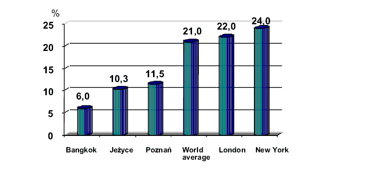
The number of cars registered in the city was 289700 (211000 passenger and 64800 lorries), whereas there were 367 passenger cars per 1000 people (2005). At the same time the overall length of roads within the city agglomeration was 1120 km (the density of the roads per 100 km2 was 330 km). Last but not least the streets' surface (596.9 ha) makes 11.5% of city's surface, whilst in the JUA the same index is even smaller - 10.3%. However, both of these indices are relatively low comparing to the other cities and world average index (Fig.2.).
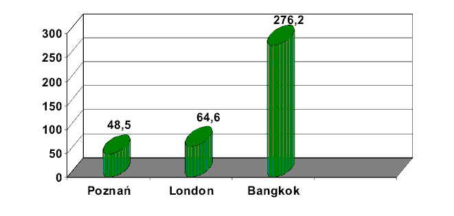
This situation is a result of both lack of investments in development of the traffic network and spatial problems resulting from the domination of pre-automobile times city's layout. The investigated JUA traffic network is largely based on the streets' layout created in the past. However, two stages of the greatest changes can be distinguished: The beginning of the twentieth century, when first tenement houses were built (the layout originating from this stage can be better observed in the eastern parts of the area adhering to the central business district). This network is called pre-automobile and hence it is characterized by very narrow streets. At the same time the network is dense. The 1970s, when due to the national programme of traffic network development (mostly expressways and motorways) the western part of the traffic network was converted into motorways and the transit street was converted into the thoroughfare in order to be able to receive the increased traffic volume on the international E-30 route (Warszawa - Berlin). Due to these differences in the traffic network, some the increased traffic congestion may occur. In order to check the state of the traffic network, several indices will be used. First of all the number of cars registered in the city will be compared to the city's traffic network's surface. The length of the network is not going to be used, since the 3-lane expressway will be able to receive bigger traffic volume than extremely narrow, one-way street. Instead the traffic network's surface will be used, since this value includes as well network's length as the streets width. Hence for Poznań the car/surface ratio will be 48,5 (2005). Comparing to the other cities, the index is low (Fig.3.), therefore the traffic intensity disturbances will not result in traffic jams, or at least not in kilometers long jams characteristic for the compared megacities. It can be seen particularly well in case of comparing the index of Poznań to the one of Bangkok, where the index is over 5 times higher. It means that there are 5 times more cars on the same traffic network's surface, resulting in 5 times bigger congestion. So according to the car/surface index the congestion in Poznań is quite high, nonetheless it will not cause many traffic jams. However, the index posses some limitations such as:
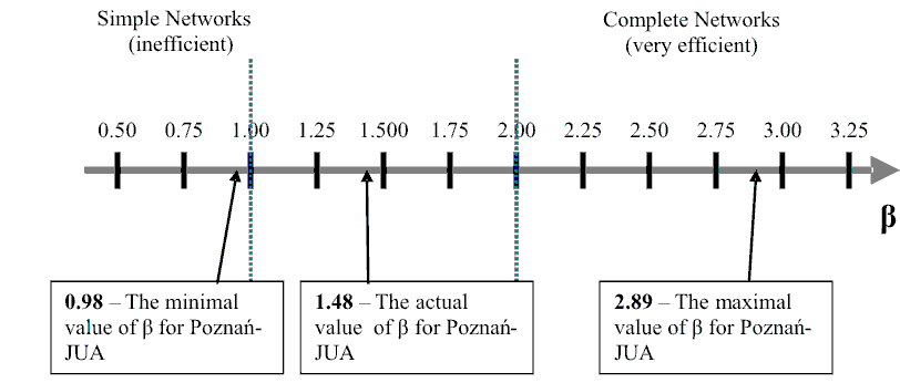
Another index that can be used to describe the research area traffic network is the beta index (β), which is one of the simplest methods to describe the connectivity of the given network [Waugh 2000]. In order to calculate the index, it is essential to calculate the number of vertices (in this case - junctions) and edges (roads' sections between the junctions) of the network. These numbers are: 54 vertices (v) and 80 edges (e) . Therefore the beta index for the JUA traffic network will be: β = ev-1 [β = 1.48] However, number 1.48 in order to be more meaningful needs to be compared with the minimum and maximum values that in this case beta index can adopt. The minimum value of the beta index in case of the investigated network is 0.98, whereas the maximum value is 2.89. The situation is presented on the axis (Fig.4.). As it is presented, the lowest value of beta index for Jeżyce Urban Area (0.98) is qualified to the group of the simplest networks (β<1), being very inefficient i.e. the connectivity is very poor. The highest value of the index (2.89) qualifies to the group of the most efficient networks (β>2), where the connectivity is the best. The actual value of the index (1.48) means that the JUA traffic network is mediocre being neither simple nor complete. Therefore in case of traffic network problems (road construction, an event resulting in closing a part of the network e.g. grade crossing closing) the flows may not find the alternative route which may result in traffic jams. Furthermore parts of the network linking the areas of the biggest significance i.e. international routes, thoroughfares, central business district (CBD) approaches - may not be able to receive the increased traffic volume and due to this fact severe traffic problems may occur [Vickrey 1969], including "triggernecks" and even "gridlocks".
Therefore in case of JUA, the most vulnerable network sections will be thoroughfares and approaches to the CBD. The other factor that can have an influence on the traffic congestion is the functional zones' layout within the JUA. It can be noticed that the functional zones within the research area are rather stretched towards the CBD creating "functional wedges" and therefore showing some similarities to the Hoyt's sector model of urban structure [Waugh 2000]. What is more, similarly to what the model of the bid-rent theory suggests, alongside the main communication routes, there will be the most profitable functional zone able to afford the highest cost of rent i.e. the business zone. It can be clearly noticed if comparing the approaches to the CBD with the functional zones within the JUA - the business areas exist only alongside the approaches. This is because of the necessity of being accessible, hence it can be linked as well that many people will be willing to concentrate in the business areas, especially during the rush hours. However, it as also anticipated that the movement of cars will be taking place mostly between the residential and business areas, whereas the industrial areas and the green areas will be less frequently the aim of the people's travel. This is because the present industry within the JUA does not employ so many people as it used to be - some factories are even being closed or restructured. Hence the main migration movements within the city are predicted to be between the residential and business urban areas and within them alike. In order to verify whether the above factors influence the traffic congestion, several checkpoints were established to investigate the traffic congestion intensity and the influence of particular factors on this congestion. However, every factor has its own influence on the traffic congestion intensity and the risk of occurrence of traffic problems (reducing or enhancing) and the extent to which it affects the intensity (the influence can be for instance negligible or very significant). Therefore it has to be stated how the particular features will affect the congestion. The hypothetical influences of particular factors investigated in research urban area are stated in the table below (Tab.1). Therefore in order to state hypothetically, whether at the given checkpoint the traffic congestion intensity will be high or low, a Synthetic Congestion Ratio (SCR) will be introduced. This ratio will indicate if the given checkpoint is vulnerable to the high congestion intensity and problems resulting from it (jams) according to the hypothetical factors' influence.
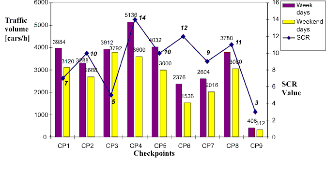
In order to find the ratio, the matrix showing the presence of particular factors at the given checkpoints must be created (Tab.2.). The SCR ratio is therefore the sum of the "influence points" at the given checkpoint and the higher the SCR is, the bigger the risk of high traffic congestion and problems resulting from it is. Therefore it can be noted that the highest risk is present at CP4 - 14, whereas the lowest one in the CP9 - 3. The other values are included between them, so it can be predicted that the highest traffic congestion and the most numerous jams will occur at CP4 and also at CP2, CP5, CP6, CP8 (the SCR value >10), whilst the lowest risk and traffic congestion alike will be at the CP9 and to some extent at CP1, CP3, CP7 (SCR<10). One more hypothetical regularity that is predicted is that during the week days the average volume of traffic will be higher than it is during the weekends. Such a situation is predicted, because during the weekend fewer people will commute to the CBD to their jobs and more people are anticipated to either stay at home or to travel rarely (e.g. to the green zone and back home). Therefore the intensity is predicted to be lower. To verify this and the previous hypotheses, the research were conducted.
ANALYSIS OF THE FACTORS DETERMINING THE MANAGEMENT OF THE TRAFFIC CONGESTION IN THE RESEARCH AREA The research was conducted four times (twice on the week days and twice on the weekend days) at 12AM and 4PM. At every checkpoint (CP) the traffic volume in every direction was measured over 15 minute period, so that it is possible to investigate not only the volume of the traffic at the given checkpoint, but also the direction from which the biggest traffic volume reaches the junction Furthermore the occurrence of the traffic jams was noted as well. However, in order to make it more precise the values obtained during the two investigations were averaged and multiplied by 12 to obtain the number of cars crossing the checkpoint per one hour. Thus the following results can be presented in a table (Tab.3.). Nevertheless it is not yet clearly visible, whether the prediction according to the Synthetic Congestion Ratio is true or not.
Therefore to make it clearer the results are presented with the use of a diagram (Fig.5.). This diagram clearly presents to what extent it was possible to anticipate the traffic congestion using the Synthetic Congestion Ratio. In several checkpoints the SCR value perfectly fits the collected data of the traffic volume. Such a situation can be observed in case of Checkpoints 2, 4, 5, 7, 8, 9. On the other hand, in cases of the other Checkpoints the ratio either fits the collected data to a very limited extent (CP1) or does not fit at all (CP3 and CP6). On the other hand, in cases of the other Checkpoints the ratio either fits the collected data to a very limited extent (CP1) or does not fit at all (CP3 and CP6). The discrepancy might have occurred because of:
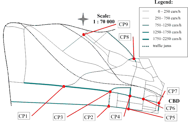
Because it is very hard to predict now what the factor might have been and to conduct once again the longer research, only the third possible cause of the discrepancy between the SCR and the traffic volume will be investigated further. In order to present clearly the traffic flows in the JUA, the flow line map can be used (Fig.6.). From the map several regularities can be observed:
The regularity observed near Checkpoints CP3 and CP6 can therefore explain to some extent the discrepancy between the Synthetic Congestion Ratio predictions and the actual traffic volume as a result of traffic jams. These jams caused a sudden slowing down of the flows and therefore the rapid decrease in number of cars per one hour could have been observed. Nevertheless, it must be stated that other factors might have also caused that the predicted factors' influence (determined using SCR) does not fit the collected data. However, still the situation at Checkpoint 1 is not clear, because the difference between the predicted and the actual congestion level exists and no traffic problems were observed there. It therefore might be a result of a factor(s) that had not been anticipated e.g. car crash. Last but not least regularity observed during the data collection was the difference between the traffic congestion intensity during week days and weekend days. According to the collected data the volume is generally lower, but the difference ranges from 3% (CP3) to even 30% (CP4). The general lower number of cars is probably a result of fact that majority of people either do not work on weekends or work less and therefore traveling with the car is limited rather to green areas or shopping centres located very often outside the city.
CONCLUSIONS During the conducted research several factors' influence on the traffic congestion intensity was investigated using self-invented Synthetic Congestion Ratio. It appears that the anticipated impact and its strength of the investigated factors was to a large extent successful (the SCR in many cases fitting the collected data values), nevertheless in some cases the discrepancies between the predictions and the reality could have been observed as well. These discrepancies proved, however, that the occurrence of traffic problems i.e. jams (which were predicted to exist as well, for example using the beta index - β) may disturb the whole traffic flows' pattern and in such a case it is very hard to predict the influence of particular factors. However, it is also possible that the list of possible factors was incomplete and there are more influential factors (for example in case of CP1 where there is no hypothetical solution of the discrepancy) that can be still a subject of the research. In the scale of the whole network the hypothesis was verified by conducting the research, that the most influential factors determining the management of the traffic congestion in the urban area are: road's significance as a communication route, central business district (CBD) approach or thoroughfare and road type (expressway, two-lane, multi-level junctions), whereas the other factors' influence is significantly smaller (streets' layout, facilities attracting people, location within a functional zone).Still it may be true that providing the research were carried out over a longer period of time at more checkpoints (i.e. large scale research) the results might be different and therefore the unsolved problems resulting from this investigation could be solved. However, the issues like finding the further factors influencing the intensity, traffic pattern changes or even traffic network modernization are problems for different investigation. REFERENCES Bulletin of Public Information of Poznań City Hall, 2006, http://www.city.poznan.pl Dighby B., Bermingham S., Butt G., 2004, The Human Environment, Heinemann Education Publishers, Oxford. London Travel Report 2004, by Group Transport Planning and Policy, Transport for London, London. Pawlak Z., 2006, Geografia ekonomiczna dla biznesu (Wyd. III), INTER-INFORM, Poznań. Szymczak M., 2002, Logistyka miejska, w: Kompendium wiedzy o logistyce, PWN, Poznań. UN - The World Urbanization Prospects: The 2005 Revision, Annex Tables, New York 2005. Vickrey W., 1969, Congestion Theory and Transport, American Economic Review 1969 Waugh D., 2000, Geography An Integrated Aproach, Nelson Thornes, Cheltenham. CZYNNIKI DETERMINUJĄCE ZARZĄDZANIE KONGESTIĄ RUCHU ULICZNEGO W OBSZARZE ZURBANIZOWANYM
STRESZCZENIE Celem artykułu jest zbadanie czynników wpływających na zarządzanie kongestią ruchu ulicznego w obszarze zurbanizowanym. Zgodnie z zaprezentowanymi przewidywaniami teoretycznymi, czynniki takie jak: migracje (dojazdy do pracy), lokalizacja w obrębie danej strefy funkcjonalnej miasta, roboty drogowe, obecność obszarów użyteczności publicznej, układ sieci transportowej, suburbanizacja, znaczenie danego szlaku drogowego, rodzaj drogi, obecność i charakter skrzyżowań, przejazdy kolejowe, mosty oraz infrastruktura transportu publicznego w różnym stopniu wpływają na wzorzec kongestii ruchu ulicznego. Poziom wpływu danego czynnika w obszarze miejskim Poznania wyrażony został za pomocą wskaźnika własnego opracowania - Syntetycznego Współczynnika Kongestii (SCR). Dodatkowo zostało przewidziane, że natężenie ruchu ulicznego w dni robocze jest wyższe w porównaniu z weekendami. W celu zweryfikowania powyższych hipotez, zostało przeprowadzone badanie polegające na ustaleniu kilku punktów pomiarowych w pobliżu skrzyżowań charakteryzujących się obecnością wcześniej wspomnianych czynników. W tych miejscach zmierzono natężenie ruchu ulicznego, co umożliwiło dalsze analizy. Pozwoliło to na wyciągnięcie wniosków, że do najważniejszych czynników wpływających na zarządzanie kongestią ruchu ulicznego w obszarze zurbanizowanym należą: ranga danego szlaku ulicznego jako trasy komunikacyjnej, położenie na szlaku dojazdu do centrum biznesoewgo miasta (CBD) lub innego ważnego obszaru użyteczności poblicznej oraz rodzaj drogi (droga szybkiego ruchu, dwupasmowa, wielopoziomowe skrzyżowania). Z kolei wpływ innych czynników (układ ulic, obszary użyteczności publicznej, lokalizacja w obrębie danej strefy funkcjonalnej) jest znacznie mniejszy. Zaobserwowano również w jednym z punktów pomiarowych, pewną rozbieżność pomiędzy oczekiwanymi a uzyskanymi wynikami, co prawdopodobnie jest wynikiem oddziaływania dodatkowego, nieprzewidzianego czynnika np. wypadku drogowego.
EINFLUSSFAKTOREN FÜR DAS STAUVERHALTEN IN STADTGEBIETEN
ZUSAMMENFASSUNG. Ziel des Artikels ist die Ermittlung von Faktoren, die das Stauverhalten in Stadtgebieten beeinflussen. Aus der Literatur ist bekannt, dass Faktoren wie: Pendler, Standorte innerhalb von funktionellen Zonen, Straßenbau, Anwesenheit öffentlicher Einrichtungen, Verkehrsnetzwerk, Vorstädte, Bedeutung der Strecke, Straßentyp, Präsenz und Bedeutung von Knotenpunkten, Bahnübergänge, Brücken oder das Vorhandensein öffentlicher Verkehrsmittel können sehr unterschiedliche Einflüsse auf Verkehrsstauungen nehmen können.
doc.dr Zbyszko Pawlak |
||||||||||||||||||||||||||||||||||||||||||||||||||||||||||||||||||||||||||||||||||||||||||||||||||||||||||||||||||||||||||||||||||||||||||||||||||||||||||||||||||||||||||||||||||||||||||||||||||||||||||||||||||||||||||||||||||||||||||||||||||||||||||||||||||||||||||||||||||||||||||||||||||||||||||||||||||||||||||||||||
Copyright © 2005 LogForum, Wyższa Szkoła Logistyki, ul.E.Estkowskiego 6, tel. 061 852 95 55, 851 06 04, tel./fax. 061 851 06 03 |